5 Years of Comelicotrekking
A bit of history
5 years have passed since the first post on Comelico Trekking, a lot of work has been done, the site was already in prototype format for a year, a format of only html and javascript written all from scratch in which the first two were present traffic and political maps which, still today, constitute the cornerstone model of all the maps on the site. Subsequently for administrative and logistical needs I preferred to entrust the backbone of the site to a pre-packaged cms and here is WordPress, this allowed me to concentrate totally on the contents. Here I churned out most of the maps and presentations with Google Earth.
In the meantime, the regulations in terms of Privacy and Security changed which required the addition of ssl security certificates and it was certainly a big step forward in terms of authentication security. Cooky policies also appeared, which are still a thorn in the side of many WebMasters not really studied like myself.
Hard hit in November 2016, the popular photo sharing site Panoramio, after being absorbed by Googlez, closed, and those who had not prepared found themselves with their work destroyed. Fortunately Comelicotrekking is always attentive to these changes in IT and had already migrated the contents to Google Drive .. it was “ONLY” to correct every link to the photos present in the KML files of the maps, understanding, with very little documentation, the functioning of the hellish cache of Google Maps servers. After several adjustments, surprise! the flat photos were no longer appreciated by the tall poppies and it was necessary to adapt and move on.
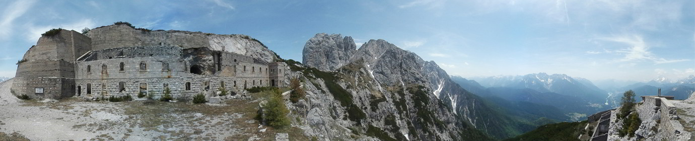
The turning point arrived, with the purchase of a Samsung Gear 360 a whole new world was opened, finally in one shot it was possible to create spherical panoramic images at 30MP and the invasion began !! The spherical photos are very captivating and certainly give inspiration to the imagination including the ability to record spherical videos at 3840×1920 at 30fps. So I had to participate in Google’s Local Guide program to be able to add my works to Maps and I must say that to date, despite the promises of free Google services never provided (although I must say that compared to other sites the rendering speeds of mine maps is enviable), I am very satisfied with the result.
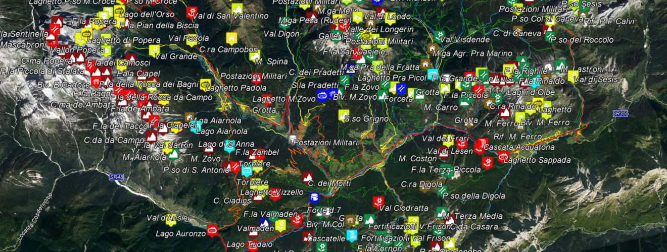
Lately, thanks to the quarantine, I was able to create as many as 9 maps showing the Points Of Interest detected during our outings. Mainly divided into classic physical points (Peaks, Passes, Valleys, Water Courses) and possible shelters in the area (Refuges, Malghe, Bivouacs, etc.)
Finally I started thinking about the future of Comelico Trekking, reluctantly embracing the Holy Grail of Social Networks (only those who saw the Internet at the beginning understand what I mean), creating snippets, metadata and buttons to bring the site to comfort ‘of the general public. Secondly, just in these days I switched to a new theme (it still requires small adjustments) with the legendary 3 portal-style columns, they will allow me to keep links to sponsors on each page that will always have excellent visibility. within all pages of the site.
The numbers of Comelico Trekking:
- 5 Years of presence
- 10.74 Gigabytes of occupied web space
- Cartelle: 1271
- File: 19741
- News Published: 86
- Site pages: 60
- Maps: 29
- Hikes: 14
- Itineraries: 1
- Waypoint: more then 600
- Traced paths: more than 90% of the territory
- Normal Photos: 1050
- Spherical Photos: 200
- App Street View Views: 779.271
And the future?
For the future Comelicotrekking will not cease to amaze:
-First of all I would like to complete the satellite tracking of the remaining paths and perhaps retrace the first works that had a lower resolution / precision.
-Secondly there are many Waipoints that lack flat and spherical photos. I would like to be able to reach some peaks not exactly famous for Trekking but equally greedy for mountaineering lovers, such as Monte Krissin, Monte Popera La Cima Nord delle Crode dei Longerin, Monte Cornon and the highest peaks of the Group del Popera in Padola. Many of these require different equipment from that used by me so far as well as technical knowledge that I do not have but I hope to find a guide suitable for the case.
-Very important would be the creation of cards on the shelters present, such as the number of beds available and advanced comfort features of the bivouacs / shelters in the area.
-Another difficult goal is to create a database of POIs to be able to search within a map in reference to the place where we are, useful for planning Trekking of many days or in case of bad weather emergency.
-Interesting would be the publication of the spherical videos that I shot coming down from some very pleasant mountains the possibility to rotate the view around and enjoy different angles on the same video but also a useful tutorial for the less experienced. Here is a preview example. Unfortunately, the amount of data is relevant in this case and at the moment there are no systems for stable use of the contents in high definition at 360 ° also thanks to the technical limit of the devices currently on the market.
-Another sector that particularly excites me is that of radio-controlled drones of the Medium / High range for some time now I am evaluating the purchase precisely to produce content from a captivating point of view. Given the progressive lowering of prices, 2020 will probably see the first videos via drone on Comelicotrekking.
Conclusioni
As already said in the introduction of the site, Comelico Trekking was born from a passion for the mountains, from the need to be outdoors to download the flaws due to daily stress combined with the unbridled passion for technology, with time it is become a healthy hobby that aims to deal, with all respect, with the territory by capturing and documenting as many elements as possible our Splendida Vallata has to give us and packaging it in the simplest and most immediate way so that everyone can enjoy the benefits that our uncontaminated environment gives us every day, especially also for those who, for various reasons, can no longer go.
The Comelicotrekking Team
P.S. I wrote this article straight away, almost in one breath, releasing the ideas and thoughts I have in my head I apologize for any grammatical or form errors present.